SmartSurf combines phone GPS, waterproof trackers, live environmental data, and Senlay's verification engine to detect dangerous rider and board situations early, reduce false alerts, and support smarter school decisions.
A school cannot stare at the horizon and understand every student's risk state. SmartSurf turns phones, trackers, and Senlay context into one operational view for classes, rentals, downwind groups, and station safety.
The valuable workflow is not a beautiful forecast screen. It is knowing which rider stopped, which board separated, who is drifting away from the safe zone, and whether wind, current, tide, or storm context explains the situation.
Senlay does not replace instructors or official rescue services. It adds evidence: wind, tide, source freshness, drift context, and why the alert should be watched, canceled, or escalated.
A stopped rider is not enough information. SmartSurf combines rider GPS, board GPS, track history, distance from shore, live weather, real sensors, marine data, and local spot logic. Senlay cross-checks the sources and returns evidence so SmartSurf can ignore, monitor, warn, or support escalation.
A basic tracker can detect that a rider stopped offshore. SmartSurf can also check track history, drift speed, distance from shore, and map position. Senlay adds the missing physical evidence: wind, current, waves, tide, pressure, rain, temperature, satellite signals, terrain, and source confidence.
The platform bridge is Senlay's verification engine and API. SmartSurf stays focused as a water-sports safety app while using Senlay for live physical-world evidence, model-vs-reality checks, and risk_event context.
During normal sessions, it can conserve battery. When a rider stops, drifts offshore, loses signal quality, separates from the board, or triggers SOS, SmartSurf can request device status, increase reporting frequency, switch into watch mode, or enter rescue mode.
The AI does not directly control the tracker. Senlay provides physical evidence, the SmartSurf Safety Engine classifies risk, and a Device Policy Layer validates safe commands before they are sent.
SmartSurf started from a real problem on the water: lost boards, drifting riders, broken equipment, offshore stops, and the dangerous minutes when nobody knows exactly what happened.
Founder of SmartSurf and Senlay. Kitesurfing and water-sports instructor with 20+ years reading wind, waves, boards, drift, launch risk, and coastal conditions.
GPS tells us where the rider is. Senlay's verification layer helps AI understand what is actually happening around them.Viktor Kryvotsiuk, founder
I saw this many times as an instructor. Boards drift away. Riders lose boards. Wind drops far from shore. Windsurfers break masts. Wingfoilers lose wings. Hydrofoils hit something underwater or get damaged. Sometimes a rider is still visible far from shore, drifting, while sunset is coming and night is close.
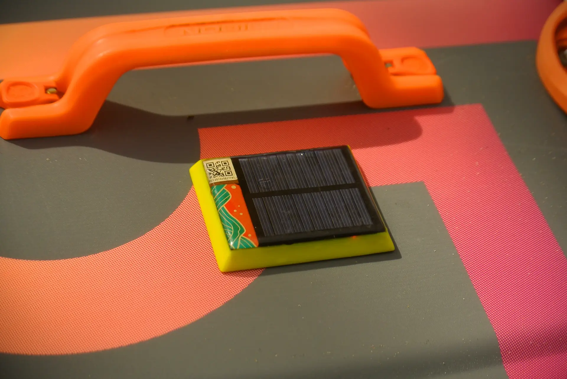
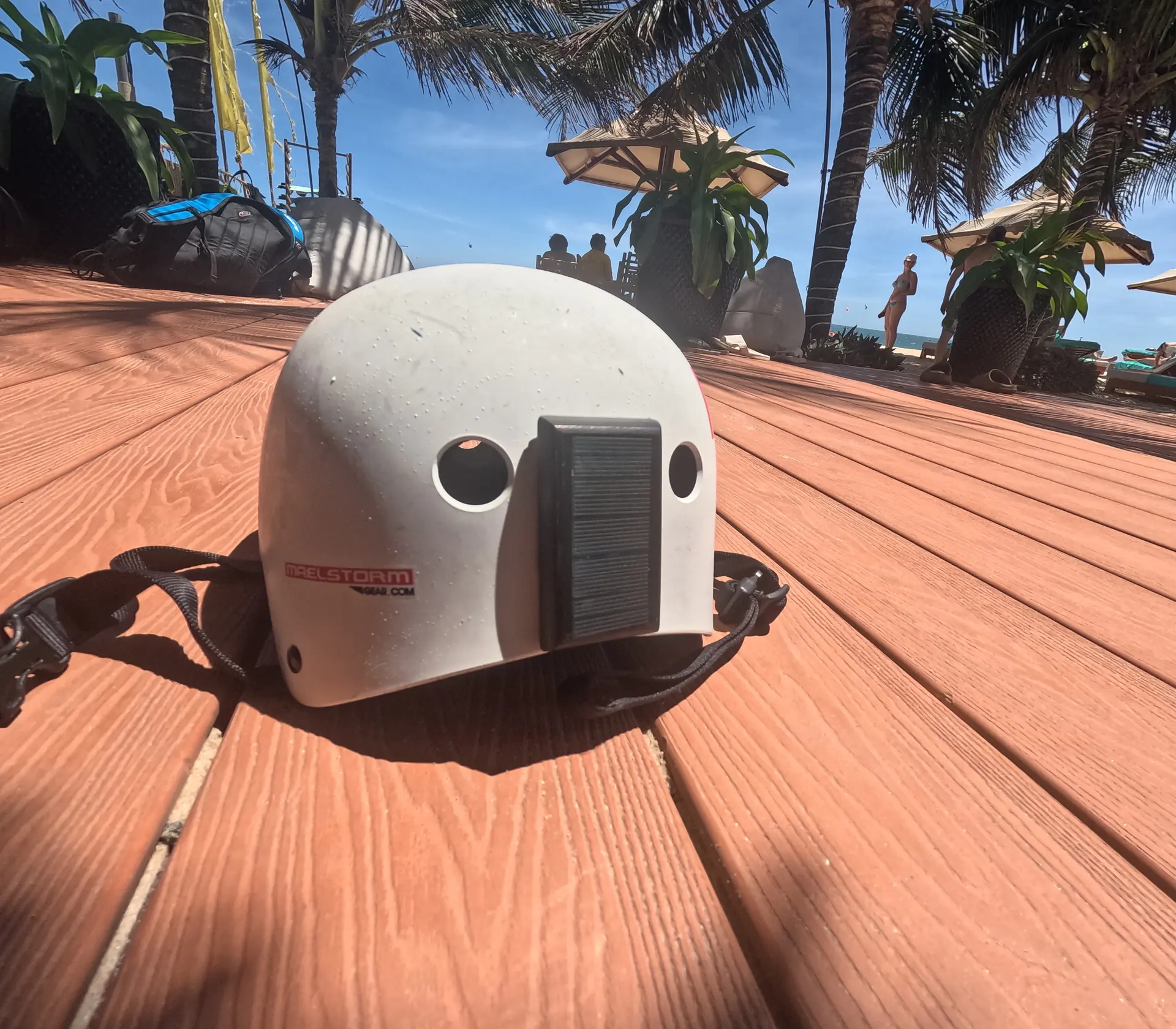
First I was solving the problem of finding lost boards and drifting riders. So I built SmartSurf: a solar-powered, epoxy-sealed GPS tracker for the rider and their board, with no buttons, no water-leak path, and magnetic switch control.
Today it sends GPS data with basic safety triggers. The bigger goal was to connect an AI model to that live location data, so reasoning is based on the actual situation instead of only trained data.
Example: a rider stops. Why? The trigger wakes up the model. It checks the situation, track history, map, behavior pattern, duration, drift speed, direction, and distance from shore. That is already useful, but still not enough to answer why the rider stopped.
Here I hit the wall. The LLM had no weather or physical-world context. It did not know wind, current, waves, temperature, atmospheric pressure, tides, fresh satellite imagery, or bottom structure. Without that context, it started guessing.
So I built Senlay — a verification engine that lets SmartSurf compare live sensors, forecast models, marine data, GPS movement, and local spot logic before the AI makes a safety recommendation.
Now, when the model reasons about a rider's situation, it connects to Senlay's verification layer and checks weather data, map data, bathymetry, tides, currents, wind, waves, distance from shore, track history, rider movement, board movement, and the surrounding environment.
The model does not just track a GPS point. It calculates the whole situation: the rider, the board, the weather, the water, the coastline, the bathymetry, the drift direction, and how those things interact in real time. The goal is simple: help before people on shore even realize the situation is becoming dangerous.
Every session can be checked against live physical-world data, then analyzed by an AI model that understands the discipline. Safety first, coaching alongside — specific feedback with source-aware context.
Use phone GPS, watch GPS, SmartSurf Tracker, or school-assigned device.
Track speed, stop duration, drift vector, distance from shore, safe zone, battery, signal, and board separation.
Check wind, gusts, waves, tide, current, METAR, live sensors, freshness, confidence, and model-vs-reality conflict.
Stopped rider, offshore drift, board separation, outside safe zone, low battery, low signal, reef/rock proximity, or manual SOS.
Send rider check, station alert, instructor review, trusted contact update, or emergency escalation depending on workflow.
After safety analysis, generate technique, fatigue, speed, maneuver, and progression insights.
Your peak speed of 38.4 knots in 22-knot wind gives a 1.75x wind ratio — that's excellent power conversion for a 12m kite on a twin-tip. Your crash at 14:24 correlates with a recorded gust to 28 knots — a 27% spike above average.
Jibe success rate climbed to 73% (up from 61% last session). Three of four failed jibes happened during gusts above 25 knots — you're stalling the kite too early in powered transitions.
Recommendation: In gusty conditions, maintain sheet tension through the turn apex before redirecting. Your clean jibes all show 80%+ speed retention when wind is steady 18–22 knots.
Safety note: You spent 12 minutes beyond the 800m offshore zone today. With cross-shore wind shifting 15 degrees north, a kite failure at that distance would result in ~25 min drift toward rocky shoreline. Consider staying within 600m when wind direction is unstable.
SmartSurf AI continuously analyzes your session against conditions, position, and behavior patterns. The goal is not just to know that movement stopped, but to understand whether surrounding conditions explain it. The same safety logic can escalate from a private rider check to trusted contacts, stations, and nearby opted-in helpers.
Wind increased from 18 to 26 knots in 20 minutes. Wave period shortened. Rider is 1.2 km offshore on a 14m kite — now overpowered.
Wind acceleration detected: +44% in 20 min. Your 14m is rated for 12-20 kts. Current conditions exceed safe range. Nearest shore: 1.2 km downwind. Recommend heading in now — if kite fails, drift to shore estimate: 18 min. Start rider check and prepare contact notification if there is no response.
Tracker on the board detects: speed dropped to 0.8 knots, movement perfectly correlates with wind drift vector (NE at 2.3% of wind speed). No human interaction for 4 minutes.
Drift confirmed: board moving NE at 0.6 kts, matching expected wind drift. Rider may be separated. Start cancel window, notify approved station contacts if configured, and attach live GPS link for review. Coordinates: 10.9334 N, 108.2835 E.
Rider's last 3 sessions show declining speed in final 30 minutes. Jibe failure rate doubles after 90 minutes. Today's session lasted 2.5 hours.
Fatigue signature identified: your average speed drops 22% after minute 90, and crash frequency triples. Your best performance window is 30-75 minutes into a session. Consider shorter, more intense sessions — or a 10-min break at the 90-min mark.
Family contacts are important, but they are often far away. On the water, the useful help may be another rider, an instructor, a kite school, a boat operator, or someone watching the same spot from shore.
SmartSurf is evolving into an opt-in safety network for riders and schools. It does not make normal sessions public. It only shares incident information when the rider has allowed it and when a possible emergency becomes relevant to the local spot.
Privacy is the default: no public routine tracking, no phone numbers on the map, and no local sharing unless the rider enables it. SmartSurf is supportive safety assistance, not a replacement for local judgment or official rescue services.
SmartSurf starts as a rider app for profiles, gear, spot checks, recommendations, and session history. The tracker adds board-mounted GPS, real-time tracking, and autonomous safety support.
Wind, swell, current, and tide data automatically layered onto your GPS track. See your speed relative to actual conditions, not in isolation.
Natural language analysis of your technique using session summary, Senlay conditions, board type, and skill level. Not generic — personal.
Profile, gear, emergency contacts, spot assessment, kite-size recommendations, session history, and post-session coaching in one mobile-first workflow.
Wind-correlated drift detection supports a graduated flow: rider check, cancel window, approved contact notification, and opt-in station or local safety network review.
Cellular GPS tracking where the SIM and local network have coverage. Kite schools can monitor students in real time; family and station links remain permission-based.
Cross-session analysis: technique evolution, fatigue patterns, and conditions that matched your best sessions. Forecasting remains advisory, not a safety guarantee.
The tracker is not a generic GPS device. It is a solar-powered, epoxy-sealed hardware extension of the SmartSurf mobile app: no buttons, no charging ports, no water-leak path, magnetic switch control, cellular GPS, and board-level safety context.
Compact solar-powered, epoxy-sealed GPS tracker with built-in cellular connectivity. Mount it on the rider or board for live location, board separation context, safety history, and AI-assisted risk reasoning.
5 trackers with fleet management dashboard. Track students in real time, receive station safety alerts, and provide AI coaching reports after each session.
Start with the mobile app, add the tracker when you need board-mounted GPS, and run a school pilot when you need a station workflow for many riders.
Use the rider app for profiles, recommendations, and session history. Add trackers and a school pilot when you need board-mounted GPS, station awareness, and Senlay-backed risk context.